Index / Search / Opuntia polyacantha var. polyacantha
§1 Plant
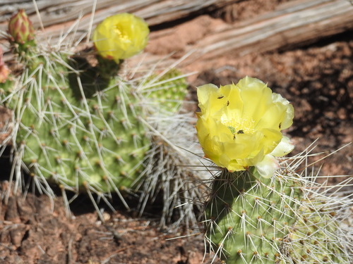
Opuntia polyacantha Haw. var. polyacantha
vernacular hairspine pricklypear — variety · Cactaceae
§2Habit & range
Habit and range
- Growth habit
- Shrub
- Duration
- Perennial
- Group
- Dicot
- Family
- Cactaceae Juss.
- Genus
- Opuntia
Native status, by region
- CAN Canada Native
- L48 Lower 48 States Native
County-level range
· 215 counties across 15 states/territories§3Cultivation
No cultivation specs.
USDA has not characterised this taxon. Roughly four out of five plants in the database lack the detailed cultivation record present here — typically because they have not been the focus of NRCS Plant Materials work. Range and distribution data are unaffected.
§4Counties, by state
Recorded in 215 counties across 15 states/territories.
Arizona view state ↗ 5 N ▾
California view state ↗ 5 N ▾
Colorado view state ↗ 29 N ▾
- Alamosa 08003
- Baca 08009
- Bent 08011
- Boulder 08013
- Chaffee 08015
- Cheyenne 08017
- Dolores 08033
- El Paso 08041
- Fremont 08043
- Garfield 08045
- Gilpin 08047
- Grand 08049
- Jefferson 08059
- Larimer 08069
- Las Animas 08071
- Lincoln 08073
- Mesa 08077
- Moffat 08081
- Montezuma 08083
- Montrose 08085
- Otero 08089
- Ouray 08091
- Pueblo 08101
- Rio Blanco 08103
- Routt 08107
- San Juan 08111
- San Miguel 08113
- Teller 08119
- Weld 08123
Idaho view state ↗ 19 N ▾
Kansas view state ↗ 1 N ▾
Montana view state ↗ 26 N ▾
- Beaverhead 30001
- Broadwater 30007
- Carbon 30009
- Carter 30011
- Chouteau 30015
- Custer 30017
- Fergus 30027
- Gallatin 30031
- Garfield 30033
- Golden Valley 30037
- Lewis and Clark 30049
- Madison 30057
- McCone 30055
- Park 30067
- Petroleum 30069
- Phillips 30071
- Powder River 30075
- Prairie 30079
- Rosebud 30087
- Sheridan 30091
- Stillwater 30095
- Sweet Grass 30097
- Teton 30099
- Toole 30101
- Valley 30105
- Yellowstone 30111
Nebraska view state ↗ 7 N ▾
Nevada view state ↗ 15 N ▾
New Mexico view state ↗ 29 N ▾
- Bernalillo 35001
- Catron 35003
- Chaves 35005
- Cibola 35006
- Colfax 35007
- Curry 35009
- De Baca 35011
- Dona Ana 35013
- Grant 35017
- Guadalupe 35019
- Harding 35021
- Lea 35025
- Lincoln 35027
- Los Alamos 35028
- McKinley 35031
- Mora 35033
- Otero 35035
- Quay 35037
- Rio Arriba 35039
- San Juan 35045
- San Miguel 35047
- Sandoval 35043
- Santa Fe 35049
- Sierra 35051
- Socorro 35053
- Taos 35055
- Torrance 35057
- Union 35059
- Valencia 35061
North Dakota view state ↗ 18 N ▾
Oregon view state ↗ 1 N ▾
South Dakota view state ↗ 6 N ▾
Texas view state ↗ 10 N ▾
Utah view state ↗ 29 N ▾
- Beaver 49001
- Box Elder 49003
- Cache 49005
- Carbon 49007
- Daggett 49009
- Davis 49011
- Duchesne 49013
- Emery 49015
- Garfield 49017
- Grand 49019
- Iron 49021
- Juab 49023
- Kane 49025
- Millard 49027
- Morgan 49029
- Piute 49031
- Rich 49033
- Salt Lake 49035
- San Juan 49037
- Sanpete 49039
- Sevier 49041
- Summit 49043
- Tooele 49045
- Uintah 49047
- Utah 49049
- Wasatch 49051
- Washington 49053
- Wayne 49055
- Weber 49057
§5Sources & provenance
USDA PLANTS
Symbol, taxonomy, distribution, cultivation specs, native status. Public domain.
plants.usda.gov/OPPOP ↗GBIF Backbone
Canonical taxonomic identity, synonym resolution, cross-refs. CC0.
gbif.org/species/7219424 ↗Record version
Cached and built locally. Source version on this record:
usda-plants-mt-2026-05-26
fetched 2026-05-26T20:46:58Z